Assessing Biodiversity in Conservation Area Near Mining Site
A Study on the Effectiveness of Conservation Efforts Through Remote Sensing and Animal Biodiversity Surveys
Introduction
Purpose
The objective of this project is to build a solution based on GIS technology that can identify the effectiveness of these conservation efforts.
Premises
Our project is built on the premise that if the conservation efforts by mining companies are effective, we should observe a notable improvement in animal biodiversity within these areas, alongside the expected increase in vegetation.
Locations
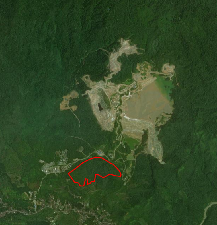 Area of Interest.
- Near Gold Mine that located in the southwest of the Batang Toru Ecosystem (BTE), Sumatra Utara.
- Mining company has designated surrounding conservation areas aimed at protecting and enhancing the local ecosystem.
Remote Sensing Indices
- Remote sensing indices are crucial tools used in the analysis of satellite imagery to monitor and assess various environmental and ecological conditions.
- The indices selected based on Parisetal et al (2023) and Sunkur & Mauremootoo (2024) research.
| Indices | Formula |
|---|---|
| Normalized Burnt Ratio | NBR = (NIR - SWIR) / (NIR + SWIR) |
| Normalized Difference Vegetation Index | NDVI = (NIR - Red) / (NIR + Red) |
| Red-edge Normalized Difference Vegetation Index | RENDVI = (NIR - Red-edge) / (NIR + Red-edge) |
| Green Normalized Difference Vegetation Index | GNDVI = (NIR - Green) / (NIR + Green) |
| Tasseled Cap Brightness | TCB = 0.3037 × Blue + 0.2793 × Green + 0.4743 × Red + 0.5585 × NIR + 0.5082 × SWIR1 + 0.1863 × SWIR2 |
| Tasseled Cap Greenness | TCG = −0.2848 × Blue −0.2435 × Green −0.5436 × Red + 0.7243 × NIR + 0.0840 × SWIR1 −0.1800 × SWIR2 |
| Tasseled Cap Wetness | TCW = 0.1509 × Blue + 0.1973 × Green + 0.3279 × Red + 0.3403 × NIR −0.7117 × SWIR1 −0.4572 ×SWIR2 |
Shannon’s Entropy
- It quantifies the uncertainty or randomness in a dataset. In the context of ecology, it is used to measure species diversity within a community.
- Calculation: The Shannon Index (H) is calculated using the formula \eqref{eq:1} \(\begin{equation} H = -\sum_{i=1}^{S} p_i \ln(p_i) \label{eq:1} \end{equation}\)
where $S$ is the total number of species. $P_i$ is the proportion of individuals belonging to the i-th species
Simpson’s Biodiversity Index
- Simpson’s Biodiversity Index measures the probability that two individuals randomly selected from a sample will belong to the same species. It is a measure of dominance and is also used to describe species diversity in a community.
- Calculation: The Simpson’s Biodiversity Index (D) is calculated using the formula \eqref{eq:2} \(\begin{equation} D = -\sum_{i=1}^{S} p_i^2 \label{eq:2} \end{equation}\)
where $S$ is the total number of species. $P_i$ is the proportion of individuals belonging to the i-th species
Data and Method
Data
This projects has 2 kinds of data: Vegetations and Animals
Vegetations
- The vegetations data were derived from Sentinel 2 Imagery from January 2019 until December 2023, 1 dataset per quarter of the year.
- Vegetations data come from NBR, NDVI, RENDVI, GNDVI, TCB, TCG, and TCW.
Animals
- The animal data were created using Survey123 to mimic real field data. The Data will be converted to Simpson’s Diversity Index and Shannon’s Entropy.
- The list of animal biodiversity data for this area were obtained from Key Biodiversity Areas (KBA) Data. This list contain:
- Panthera Tigris Sumatrae (Panther)
- Macaca sp. (Primate)
- Ichthyophis Paucidentulus (Amphibia)
- Erythropitta Venusta (Bird)
- Tapirus Indicus (Tapir)
- Neolissochilus Thienemanni (Fish)
Please note that the animal location and abundance that presented here is dummy data and used for illustrate the solution’s capability only.
Method
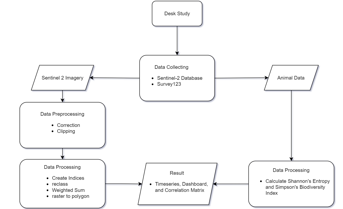 Workflow.
Results
Conclusion
Based on the results, the project successfully developed a GIS-based solution that effectively identifies and evaluates the impact of conservation efforts, also providing valuable insights for future planning and implementation.